Cenotes formed because the Yucatán Peninsula is a huge slab of limestone, and limestone dissolves. For a very long time, slightly acidic rainwater has soaked into the rock and carved out caves and flooded passages underground. When the roof of one of those caves gets thin enough and collapses, it opens a window onto the groundwater below. That window is a cenote.
The asteroid you may have heard about, the one that hit near Chicxulub about 66 million years ago, did not dig the cenotes directly. What it did was leave a buried crater that changed how groundwater moves in one part of the peninsula, which is why cenotes in the state of Yucatán line up in a striking arc called the Ring of Cenotes. Here is how both pieces fit together, and what it means for the cenotes you can swim in near Cancún.
What is a cenote, exactly?
A cenote is a natural sinkhole that exposes groundwater. The word comes from the Yucatec Maya ts'ono'ot (also written dzonot or tz'onot), usually translated as a hole or cavern with water. Some cenotes are wide open lagoons, some are half-covered by a rock ceiling, and some are caves you enter through a small opening. We break those down in our guide to the types of cenotes.
What they all share is the rock they sit in. The peninsula is a low, flat platform of limestone, which is mostly calcium carbonate. That single fact explains almost everything else.
How did rainwater carve the caves?
Rain picks up carbon dioxide from the air and soil, which turns it into a weak carbonic acid. When that water seeps into limestone, it slowly dissolves the rock. Over very long periods, small cracks widen into tubes, galleries and whole cave systems. Geologists call this kind of landscape karst.
On the Caribbean side of the peninsula, there is an extra ingredient. Close to the coast, a layer of fresh rainwater floats on top of heavier seawater that pushes in underground. Researchers who study these caves have found that the zone where fresh and salt water mix is especially corrosive to limestone, and cave passages tend to be widest right around that boundary. If you have ever seen a diver's photo of a shimmering, blurry layer in a cenote, that is the halocline, the line where fresh water meets salt water.
Why were the caves once dry?
Sea level has not always been where it is today. During the Last Glacial Maximum, around 20,000 years ago, so much water was locked in ice sheets that the sea stood roughly 120 meters (about 390 feet) lower. The groundwater level dropped with it, and many caves that are flooded today were full of air.
That matters for two reasons:
- Collapse. Without water to help hold them up, some cave roofs gave way, opening new sinkholes.
- Stalactites and stalagmites. These formations only grow in air, when dripping water releases carbon dioxide and leaves calcium carbonate behind. Finding them underwater is proof that a cave was once dry.
When the ice melted and the sea rose again, the water table rose too and flooded the caves. Many of the formations you see in clear cenotes today were built during those dry periods.
Why are there no rivers on the Yucatán Peninsula?
Look at a map of the northern peninsula and you will notice something odd: almost no rivers. Researchers at UNAM describe it plainly. There are no surface rivers and no mountains shaping the landscape. Rain does not run off across the ground. It sinks straight into the porous, fractured limestone and travels underground instead.
The result is a vast, connected body of groundwater that some scientists call the Maya Aquifer. It is not one big underground lake but a tangle of conduits, flooded caves and storage zones. Cenotes are the places where you can see it. For the ancient Maya, and for many communities today, that made cenotes the main source of fresh water. It is also why cenotes carried so much religious meaning, a story we cover in our posts on Chaac, the Maya rain god and Xibalbá, the Maya underworld.
What does the Chicxulub impact have to do with cenotes?
About 66 million years ago, an asteroid roughly 10 kilometers (6 miles) wide struck what is now the northern coast of Yucatán. The impact is widely linked to the mass extinction that ended the age of the dinosaurs. The crater is named after the town of Chicxulub, north of Mérida, and its center lies just offshore.
You cannot see the crater. It is buried under as much as a kilometer of younger limestone and marl that piled up over millions of years. Geophysicists working for Mexico's state oil company, Pemex, first noticed a circular pattern in gravity and magnetic data in the late 1970s. In 1991, a team including Alan Hildebrand, Glen Penfield and Antonio Camargo published evidence identifying it as an impact crater.
The Ring of Cenotes
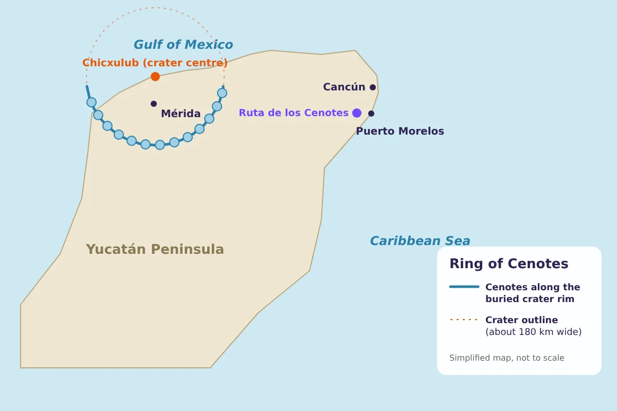
Around the same time, researchers noticed something visible from space. In satellite images of northwestern Yucatán, cenotes cluster in a clear arc. A NASA-indexed study by Kevin Pope, Adriana Ocampo and Charles Duller measured the ring at about 165 kilometers across and proposed a mechanism:
- The buried crater rim created a boundary in the rock, with less fractured limestone on one side and more fractured limestone on the other.
- That boundary acts as a barrier that channels groundwater along it.
- Concentrated water flow means faster dissolution, and faster dissolution means more cave collapse, so more cenotes form along that line.
In other words, the asteroid set up the pattern, and rainwater did the digging, tens of millions of years later.
The Mexican government's submission to UNESCO describes the ring as a semicircular belt about 5 kilometers wide that runs from around Celestún on the west coast to Dzilam de Bravo on the east, passing through municipalities such as Homún. More than 2,000 cenotes have been registered in the area, and in 2006 the Ring of Cenotes was added to the Ramsar list of Wetlands of International Importance. It has also been on Mexico's UNESCO World Heritage Tentative List since 2012.
Are the cenotes near Cancún part of the Ring of Cenotes?
No. This is a common mix-up. The Ring of Cenotes is in the state of Yucatán, around Mérida. Puerto Morelos, Cancún and the Ruta de los Cenotes are in Quintana Roo, far to the east of the ring.
The cenotes along the Ruta de los Cenotes belong to the same limestone platform and the same karst groundwater system, but their layout is not explained by the crater rim. On the Caribbean side, geologists link cave development mainly to the mixing of fresh and salty groundwater near the coast and to the rise and fall of sea level over the ice ages. The flooded cave systems studied along this coast run several kilometers inland, and the cenotes there are often openings into those long, wide caves.
So when you swim in a cenote off the Puerto Morelos road, you are floating in the same kind of groundwater that fills the ring, just shaped by a different chapter of the story.
Why cenotes need protection
The same geology that makes cenotes beautiful makes them fragile. UNAM researchers point out that in karst, what happens on the surface reaches the groundwater almost immediately. There is little soil to filter pollutants, and rain can reach the aquifer within hours or days. Wastewater, fuel and even sunscreen can travel through the system.
A few simple habits help:
- Shower before you get in, if the site has showers.
- Use only biodegradable sunscreen, or skip it and cover up instead. Many sites, including ours, require this.
- Do not touch or stand on stalactites, stalagmites or roots.
- Take all trash with you.
Our cenote prep guide covers what to pack.
See a jungle cenote near Cancún
Mayan Jungle Rush is at km 18.5 of the Ruta de los Cenotes, about an hour from the Cancún Hotel Zone. If you want quiet time in the water, our adults-only Cenote Tour spends about three hours at a jungle cenote with a Maya snack. If you would rather combine a swim with ATVs and ziplines, several of our combo tours include the cenote, and one of our ziplines crosses right over it. For more swimming spots along the road, see our Ruta de los Cenotes guide.
Frequently asked questions
How long does it take for a cenote to form?
It depends on the cenote. The caves behind them develop over very long geological periods as rainwater dissolves limestone, and the final roof collapse can happen suddenly. Scientists do not give a single age that applies to all cenotes.
Did the asteroid that killed the dinosaurs create the cenotes?
Not directly. The Chicxulub impact left a buried crater whose rim channels groundwater, which is why cenotes cluster in a ring in the state of Yucatán. The cenotes themselves were dissolved by rainwater much later.
How many cenotes are there in the Ring of Cenotes?
Mexico's UNESCO submission says 2,241 cenotes had been registered in the ring area, which it estimated to be about 70 percent of the total.
Are cenotes fresh water or salt water?
Mostly fresh water. Near the coast, many cenotes and caves have fresh water on top and salt water below, separated by a visible halocline.
Swim in a jungle cenote
Spend 3 hours at our cenote on the Ruta de los Cenotes, with pickup from Cancún.
See the Cenote TourSources
- Ring of Cenotes of Chicxulub Crater, Yucatan – UNESCO World Heritage Tentative List
- Chicxulub cenote ring study, Pope, Ocampo and Duller – NASA Technical Reports Server
- Karst and Colors on the Yucatan Peninsula – NASA Earth Observatory
- The Water under Our Feet: Karst, Infrastructure and Water Vulnerability – UNAM Internacional
- Speleogenesis: How were caves and cenotes formed? – Emiliano Monroy-Ríos, Northwestern University
- Cave development on the Caribbean coast of the Yucatan Peninsula – USF Digital Commons